Crisis Management
Institutional Protection Framework
State Crisis Management Group (SCG)
Chaired by the Chief Secretary, this apex body coordinates statewide disaster and fire response at the highest governmental level.
Crisis Management Cell
Headed by the PCCF & HoFF, this cell translates policy into field action across all forest circles.
Divisional Crisis Control
14 Specialized Divisions manage 11 districts, ensuring 3+ C&RD blocks are monitored by each division through Range and Beat offices.
Community Frontline (VFFCC)
Local Village Forest Fire Control Committees act as the primary defense, detecting and combating fires in community lands.
Real-Time Satellite Monitoring
In collaboration with Forest Survey of India (FSI), we utilize satellite detection for real-time fire incidence mapping.
- Daily Satellite Alerts
- Digital Fire Risk Zonation
- HQ & Range Control Rooms
The 5% Challenge
While only 5% of Meghalaya's forests are under direct government control, the remaining 95% are community-owned, presenting unique challenges for crisis management.
NAPFF Integration
In line with the National Action Plan on Forest Fire, we have completed digital risk zonation for the entire state.
Community Incentives
High-performing VFFCC members are given annual honorariums to encourage vigilance and timely reporting.
Crisis Plan
Ministry-approved plan including work schedules, digitization of fire-prone maps, and strategic evaluation.
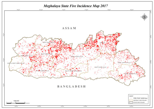
Map Intelligence
- FSI Integration: Daily detection points received directly from the Forest Survey of India satellites.
- Zonation Mapping: Statewide digitization of fire-prone zones categorized by risk levels.
- Rapid Alert: Real-time dissemination of detected points to 14 divisions and 343 village committees.
- Verification: Field assessment protocols established for all 11 districts despite hilly terrain challenges.